Sorry, www.ridge.co.uk is not supported by Internet Explorer.
Sorry, www.ridge.co.uk is not supported by Internet Explorer.

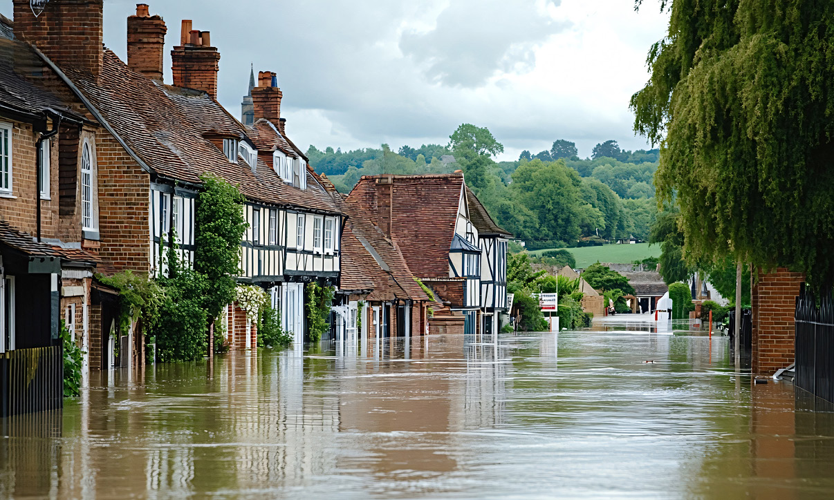
Flood risk is an increasingly influential factor in planning decisions, as climate change is making heavy rainfall and storms both more frequent and severe. Today, 6.3 million properties in England are at risk of flooding; by 2050, this will rise to 8 million, or one in four. To win planning approval, new schemes must demonstrate that the occupants will be safe over the lifetime of the development, and that they will not increase flood risk elsewhere, in accordance with recently updated government policy.
In January and March 2025, the Environment Agency (EA) released major updates to its “Flood Map for Planning” service, the evidence base that local authorities use to approve or reject planning applications in England. For the first time, it incorporates the latest UK climate projections from the Met Office, allowing planners, designers and developers to see how a site will be impacted by flooding over the next century.
This is a valuable tool, but it is still, for the most part, a broad-brush picture of flood risk. In reality, the likelihood of flooding and its impacts are determined by local factors that aren’t necessarily captured. The Flood Risk Management team at Ridge supports clients by filling this knowledge gap. We drill down into the data to guide development to the safest possible locations, maximising housing delivery and values.
Flood mapping is complex, but we’ve boiled it down into five questions that developers should ask.
The first thing we do is look at the quality of the EA data – and what it might be missing. Increasing the detail and resolution of a map can show that the risks are lower: that flooding would only affect part of a site, that it would be less severe, or that it would only occur under very extreme conditions.
The EA provides maps showing the probability of flooding from rivers and the sea (Flood Zone maps), surface water and reservoirs, both now and in the future. These maps are primarily based on a topographic aerial survey using LIDAR, which produces a 3D scan by bouncing laser pulses off the Earth’s surface. The recent updates have improved the accuracy and consistency of the data, but it is still at a national scale and makes conservative assumptions about site-specific factors such as the capacity of drainage systems, how much water the soil can absorb, or features such as walls, bridges and culverts that are not picked up by LIDAR. These can have a major influence on the likelihood of flooding.
In some areas where properties have previously flooded, the EA also provides detailed, local-scale modelling. This incorporates measured surveys of river channels, bridges and culverts, as well as long-term hydrology records from rain and river gauges. Even these more detailed models may not represent the subject site well, often lacking up-to-date hydrology data and site-specific topographic surveys. In most cases, the EA will require the model to be updated to inform a planning application, even if only to take into account the latest climate change allowances.
When a client asks us to look at a site, our in-house GIS system gives us instant access to information that is not available on the EA website. This includes its flooding history, the availability and age of any local models, and the hazard to the public rather than just the probability of flooding. That means we can very quickly advise on the accuracy of the flood maps, and whether they can or need to be improved.
Where there is an existing local model, our next step is to request it from the EA, in order to review the inputs and methodology. We can then advise whether it is likely to over or under-represent the risk of flooding, and whether it’s worth carrying out further analysis.
If the risk is likely to be greater, we may suggest that the developer pause progression of the masterplan or architectural design, and recommend alterations to the layout and/or potential flood mitigation solutions to ensure the proposals will ultimately be deliverable.
A model may also be overly precautionary – for example, because it was carried out for a different purpose, flood mitigation has since been implemented, site-specific features are not accurately represented, or the hydrology is out of date. In these cases, updating the model can sometimes reduce the flood plain area, opening up more land for development and negating the need for costly flood mitigation works such as flood defence walls, embankments or raising the ground level.
Once we understand the risk properly, we can explore ways to reduce or mitigate it. We can advise on how to fit as much development as possible into lower-risk parts of a site, or how ground levels might be manipulated to alleviate flood risk in areas that are more favourable for development. Water always has to go somewhere, but we can alter the floodplain to create greater opportunities.
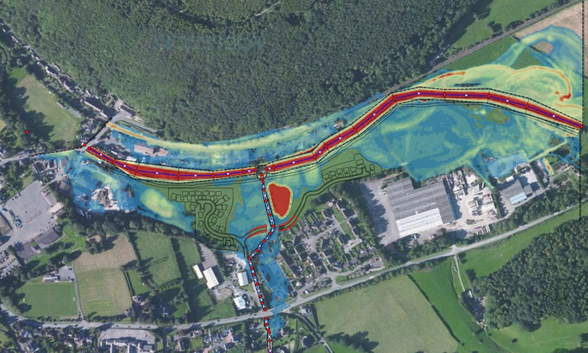
A typical solution is to raise ground levels where development is preferred and lower them where land can be sacrificed, to ensure flood risk is controlled on site and not increased elsewhere. We can then produce flood maps for existing and post-development scenarios, including the extent, level and depth of flooding, flow rates, hazards to the public, and detailed comparison plots to demonstrate the impact of the proposals.
This is the art of flood modelling, and it’s always a collaborative exercise, involving many disciplines from architecture and masterplanning to transport planning, ecology and engineering. Our flood modelling team works closely with others on the project to guide development to the most appropriate locations – balancing flooding with other constraints and mitigating the risks to residents and surrounding communities.
Under the National Planning Policy Framework (NPPF) for England, developments must pass the “sequential test”. This means that they will not be permitted if there are suitable sites with a lower risk of flooding, unless it can be demonstrated that the wider sustainability benefits outweigh the flood risk, and that the development will be safe for its users throughout its lifetime, without increasing flood risk elsewhere.
But several recent planning appeals have allowed schemes to go ahead, finding that in the planning balance, a heightened risk of flooding is outweighed by the pressing need to meet housing targets. The UK has a huge shortage of housing – the government is aiming to build 1.5m homes within this parliament – and they can’t all be located in low-risk areas.
The planning practice guidance that supports the NPPF was updated in September 2025. This no longer requires the sequential test to be applied if a site-specific flood risk assessment demonstrates that the development will be safe from surface water flood risk over its lifetime and will not increase flood risk elsewhere.
This means that on-site flood management measures, evidenced through modelling, can enable development within areas that are currently shown to be at risk of surface water flooding. This will also benefit communities by reducing flood risk on neighbouring land, helping to tip the planning balance and deliver much-needed housing.
Although the outputs from detailed flood models are often used to support planning applications, these maps are not automatically updated on the Flood Map for Planning. So even when permission is granted, the site may still be shown as prone to flooding. This will be a concern for insurers and could lower property values.
One way to protect against this is with a “flood map challenge”: a request to the EA to reclassify a site based on updated baseline information. This can result in significantly increased land values and sale prices. Our team has successfully challenged the flood maps on a number of projects. It’s important to note that flood map challenges do undergo a rigorous, lengthy approval process, and the EA may request that the scope of the modelling be expanded. We therefore recommend that any challenge is run separately, so that it does not delay the planning application process.
Flood risk modelling is an ever-evolving science, and our ability to predict flooding and to develop strategies to mitigate it is improving all the time. The EA’s updated flood maps are a valuable addition to the UK’s climate resilience toolkit – but like any tool, it’s important to use them appropriately and to be clear about their strengths and limitations. Ridge’s flood risk management team can provide critical early insight, helping you to choose the right site. We work collaboratively to support design teams and developers to maximise the potential of a site to deliver the safe, resilient homes that the UK urgently needs.
Brendan McCarthy is a Partner at Ridge leading the Flood Risk Management team. He can be contacted at brendanmccarthy@ridge.co.uk

Thank you for signing up. We look forward to sharing updates with you